
Page 473 - Economia Azul - versão: inglês
P. 473
to optimize routes and save fossil fuels, information without making it confusing signals or even satellite navigation, leads cyber threats, with impacts that transcend
which additionally leads to a reduction in and overwhelming the user is generating to the need to adopt measures of strict the digital world. This is because, when
CO2 emissions from the merchant fleet. important research in the search for deci- cyber protection, equal to or greater than controlling critical systems through com-
Artificial intelligence solutions, embedded sion support solutions with the use of ar- those adopted on an internet-connected puters, it is possible for an action initiat-
in decision support and route planning tificial intelligence and augmented reality computer. At the same time that it allows ed in the digital world to have concrete
software, use long-term weather-ocean- resources, which aim to improve maritime great gains in the operation of ships, in- effects in the real world, with an impact
ographic forecasts to suggest important situational awareness. creasing efficiency and reducing the need on the operation of the ship and on the
route changes to ships. These changes aim The Brazilian Navy is working inten- for manpower, the digitization of systems safety of the crew, passengers and the en-
to avoid adverse situations of wind, current sively on the specification and implemen- makes room for the risks arising from vironment (Armor Shield, 2021).
or seakeeping (response to waves) and pro- tation of the Amazônia Azul (Blue Ama-
vide the optimization of fuel consumption zon) Management System (SisGAAz) that Figure 2. CITRA and AVP visualization console
in an ocean crossing. will be able to monitor, with multiple data
The monitoring of maritime and port sources, the maritime space adjacent to
traffic has undergone an important para- the Brazilian coast, called Amazônia Azul
digm shift since the establishment of sat- (Blue Amazon). One of the first products
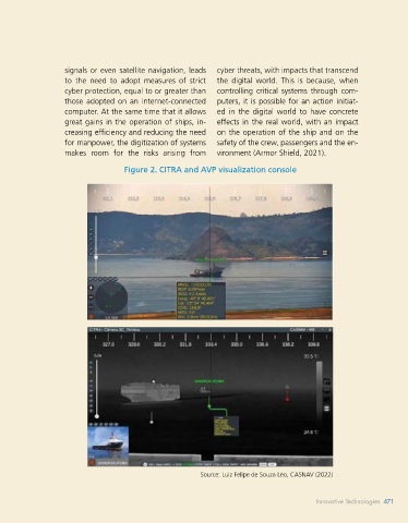
ellite positioning systems that began to developed for this purpose is the Aug-
provide the navigator with his precise po- mented Reality Tactical Image Console (CI-
sition in real time, and this position began TRA) developed by CASNAV. It integrates
to be shared by radio with ground control surveillance cameras, sensors such as AIS
stations. Sharing position information be- and ARPA Radar, located on land or on
tween navigators helps to improve navi- board, with artificial intelligence and aug-
gation safety in regions of intense traffic mented reality resources (LÉO, 2022). The
and low visibility conditions. Today, more result of this integration is the real-time
than 30 years after the popularization of presentation of high-definition images of
GPS in the maritime environment, there the fusion of sensor information with an
are resources on board that automatically intelligent synthetic layer that provides the
share the position, heading, speed, status, port operator with important data from
and characteristics of vessels, such as the the monitored targets, as can be seen in
Automatic Identification System (AIS). Ad- the images below. CITRA, in its Virtual As-
vances in the data telemetry sector allow a sistant Bridge (AVP) version, can also be
wide range of information to be sent and used on board a ship and offer the nav-
received by vessels and exchanged with igator a more accurate and harmonious
shore control stations or even with the tactical scenario, integrating data from
common user over the internet. multiple sources on a single platform, thus
A recent technological challenge is to improving safety at navigation.
harmonize the amount of information Although encouraging, the use of
available in the environment of a mod- computational resources in maritime ac-
ern walkway compatible with the oper- tivities that make use of external data
ator’s cognitive capacity. The difficulty for their processing, such as the use of
found in balancing the presentation of electronic nautical charts, receiving AIS Source: Luiz Felipe de Souza Léo, CASNAV (2022)
470 BLUE ECONOMY Innovative Technologies 471
Innovative Technologies 471