
Page 630 - Economia Azul - versão: inglês
P. 630
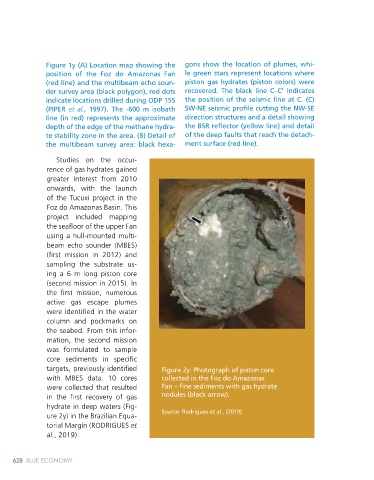
Figure 1y (A) Location map showing the   gons show the location of plumes, whi-                                      From the seafloor mapping, several    gas  hydrates  is dispersed nodules in the
               position of the Foz do Amazonas Fan      le green stars represent locations where                                 submarine mounds were identified with    mud matrix, massive layers 10 cm thick have
               (red line) and the multibeam echo soun-  piston gas hydrates (piston colors) were                                 relief between 10-20 m in height, in water   also been recovered (KETZER et al., 2018).
               der survey area (black polygon), red dots   recovered. The black line C–C’ indicates                              depths of 1000-1800 m (Figure 3y). These
               indicate locations drilled during ODP 155   the position of the seismic line at C. (C)                            features are located near the edge of the   Figure 3y: Seafloor images generated
                                                                                                                                                                          from a multibeam echo sounder survey,
               (PIPER  et al., 1997). The -600 m isobath   SW-NE seismic profile cutting the NW-SE                               gas hydrate stability zone and associated   illustrating zones of seafloor fluid leaks
               line (in red) represents the approximate   direction structures and a detail showing                              with faults; in one of them the gas hy-  associated with gas plumes in the water
               depth of the edge of the methane hydra-  the BSR reflector (yellow line) and detail                               drate samples were recovered. Deep-sea   column: (A) Plumes aligned NW- SE illus-
               te stability zone in the area. (B) Detail of   of the deep faults that reach the detach-                                                                   trating the variation in height according
               the multibeam survey area: black hexa-   ment surface (red line).                                                 mounds are often associated with gas     to the increase in water depth; the red
                                                                                                                                 seeps (plumes) recognized in the water
                  Studies on  the occur-                                                                                         column (KETZER et al., 2018, 2019). Seeps   dashed line corresponds to the C-C’ seis-
                                                                                                                                                                          mic line (Figure 1y);
               rence of gas hydrates gained                                                                                      located near the edge of the gas hydrate   (B) Set of aligned plumes, associated with
               greater interest from 2010                                                                                        stability zone may be linked to hydrate dis-  the upper limit GHSZ (dashed yellow
               onwards,  with  the  launch                                                                                       sociation  related  to  contemporary  ocean   line), isobath ~600m, note the presence
               of  the  Tucuxi  project  in the                                                                                  warming (KETZER et al., 2019). Although   of submarine mounds (arrows).
               Foz do Amazonas Basin. This                                                                                       the most common form of occurrence of                 Source: Authors elaboration, (2022)
               project included mapping
               the seafloor of the upper Fan
               using a hull-mounted multi-
               beam  echo  sounder  (MBES)
               (first mission in 2012) and
               sampling  the  substrate  us-
               ing a 6 m long piston core
               (second mission in 2015). In
               the first mission, numerous
               active  gas  escape  plumes
               were identified in the water
               column and pockmarks on
               the seabed. From this infor-
               mation, the second mission
               was formulated to sample
               core sediments in specific
               targets, previously identified    Figure 2y: Photograph of piston core
               with MBES data. 10 cores          collected in the Foz do Amazonas
               were collected that resulted      Fan – fine sediments with gas hydrate
               in the first recovery of gas      nodules (black arrow).
               hydrate in deep waters (Fig-
               ure 2y) in the Brazilian Equa-    Source: Rodrigues et al., (2019).
               torial Margin (RODRIGUES et
               al., 2019).


     628   BLUE ECONOMY                                                                                                                                                               State of the Art of Gas Hydrate Occurrences  629