
Page 629 - Economia Azul - versão: inglês
P. 629
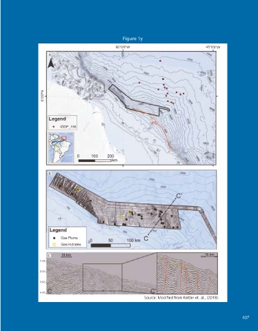
Figure 1y
                                                    º
                                                                                           º
                                                   50 0'0"W                              45 0 ' 0 "W


                   z
                   b
                   b
                   o
                   LO

                      Legend
                        •  IODP _ 155


 Figure X3: Discoveries of the occurrence    PROJECT*) and Rio Grande Cone, Pelotas
 of GH in Brazilian territory: Amazon   Basin (CONEGAS Project*) *Projects de-
                                                     '=D
 Fan, Foz do Amazonas Basin (TUCUXI     veloped by IPR/PUCRS.       o   o  o  '  o
 Source: Adapted from Ketzer et al., (2021).  100   200
                                                 km
 The Foz do Amazonas  Deep-sea Fan Gas Hydrates Province
 The Foz do Amazonas Cone is approxi-  about the sediments deposited there were
 mately 250 km from the mouth of the Am-  cored and profiled (FLOOD et al., 1995).  - 3 0 0 0
 azon River. This sedimentary Fan extends   The movement of this thick sequence of   -2800
 for 700 km seaward, from the outer edge   sediments, predominantly composed of mass
 of the continental shelf to water depths   wasting and turbidite deposits (channel-le-
 of more than 4,000 m in the Demerara   vee), caused the gravitational collapse of the
 Abyssal Plain (Fig. 1y). It occupies an area   region, resulting in the establishment of ex-
 of  330,000 Km² and 9 km of sedimentary   tensional dynamics in the proximal part and

 thickness (SILVA et al., 1999; DAMUTH and   compressive in the distal part, with the conse-
 KUMAR, 1975). This feature began its for-  quent formation of normal faulting and fold-
                        •
 mation in the Lower Miocene, through the   ing systems, responsible for the formation of   *  Gas Plums
 accumulation of sediments whose source   gaps of up to 500 m in the seabed (FLOOD   Gas Hidrates
 area is attributed to the uplift of the Andes   et al., 1991; REIS et al., 2010, 2016; SILVA et   10km   10 km
 Mountains and the consequent reversal of   al., 2016). The triggering of giant mass wast-  1.00
 the direction of the Amazon River to the   ing events (BTMs) has been associated with
 northeast (FIGUEIREDO  et al., 2009). The   variations caused by climate during sea level   �  2.00
                 1-
 IODP mission #155 made important contri-  changes (MASLIN et al., 2005). More recent-  3.00
 butions to the knowledge concerning the   ly, during the Neogene, BTMs are associated
 tectono-sedimentary evolution of this area.   with tectonic activity within the upper part of   4.00
 17 wells with up to 450 m of information   the slope (REIS et al., 2016).  Source: Modified from Ketzer et. al., (2018).


                                                                                                         627
 626   BLUE ECONOMY                                                    State of the Art of Gas Hydrate Occurrences 627