
Page 453 - Economia Azul - versão: inglês
P. 453
products also allow intermediate users and also by improving the management and Sectors Applications and Services Key-Variables
specialists to develop services demanded data processing of Brazilian systems, which
by the Blue Economy when possible. This is can be centralized or distributed. CMEMS Seafood Decision making on fisheries, fish Coastal and estuarine EOVs
farming, shrimp farming, and harmful
the case of the applications of SisMOM and has an efficient system for organizing ob- algal bloom and biological alerts
the Observatório do Mar at UFPR. Howev- servational data distributed throughout Coastal services Adaptation to coastal erosion Sea level, sea state, currents,
er, among the identified sectors of the Blue Europe. This model could be used to inte- Port management bathymetry
Economy, many services still need improve- grate regional and federal initiatives in Bra- Sargassum and dangerous algae bloom Biogeochemical parameters
ments in the observational system of coast- zil, aiming to collect and provide access to Water quality
al waters, not only by increasing the num- the full content of observations available to Detection of marine litter with citizen
participation
ber of platforms and measurements, but a vast community of users. Merchant Navy and Ship route planning Surface parameters: pressure,
navigation Search and rescue precipitation, wind, ocean state,
Port management currents
Table 1. List of Blue Economy sectors, applications and services Natural resources Exploration of oil, gas and mineral Winds, sea state and surface
and key variables in terms of Essential Ocean Variables (VOEs) and energy resources currents
and Essential Climate Variables (VCEs) Wind farms
Source: own elaboration
Sectors Applications and Services Key-Variables
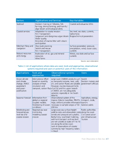
Table 2. List of applications where data are used, tools and approaches, observational
Climate and Seasonal forecast Upper ocean heat content and systems required and users or potential users of the information.
adaptation Climate projections flows/transport
Coral bleaching monitoring Air-sea flows Applications Tools and Observational systems Users
Sea level rise Sea level, bathymetric mapping approaches required
Water quality, eutrophication Currents
Ocean health Bloom and sargassum drift nutrients, distribution of O , Ocean climate International effort Large-scale CMEMS products such Search
2
Pollution and scattering of garbage CO , pH and climate based on monthly as transports (volume, heat, salt), Decision makers and
2
Acidification in the ocean change, AMOC analyses of heat pH, and carbon fluxes are suitable. government officials
Marine conservation Protection programs (e.g., TAMAR) All EOVs assessment circulation and However, routine measurements
and biodiversity species mapping and ocean transport, carbon flux of pCO2 and the upper branch
Protection of marine areas (e.g., acidification of AMOC are not adequately
Fernando de Noronha) sampled, especially in the South
Science and Research Projects: Rede Clima, REMO, All EOVs and ECVs Atlantic.
innovation PIRATA, PNBOIA Seasonal forecast Information from Observational system of the Agriculture, energy,
Oceanic policies and Defense, policing and military activities All EOVs and ECVs, specific global or regional tropical Atlantic (satellites, PIRATA, transport, trade,
governance and Marine conservation areas in Brazil mappings of ecosystems and coupled models; Argo, drifters) provides information tourism
mitigation Public policies for adaptation to coastal marine biodiversity in regions of Monitoring of ocean necessary to sample ranges of 50- General public
erosion and waste management interest conditions 200 km
Education, public Water quality and status Biogeochemical and biological Monitoring and Regional sea level Large-scale sea surface height Public authorities
health and Weather, surfing and bathing parameters forecasting sea monitoring satellite data and atmospheric data along the coast
recreation conditions; Surface parameters: pressure, level rise and Modeling coastal (winds and pressure) are suitable; Civil construction
precipitation, wind, ocean state, coastal erosion erosion Bathymetry, local tidal modeling, and infrastructure
currents sediment transport and sea level Tourism
Extremes, dangers Extreme rain and drought events Surface parameters: pressure, are not suitable at scales of 1 to 10
and safety Heat waves in mainland Brazil precipitation, wind, air km along the entire coast;
temperature, ocean state, Lack of observations of coastal
currents currents by high frequency radars
in Brazil
450 BLUE ECONOMIY From Observation to Data Use 451