
Page 749 - Economia Azul - versão: inglês
P. 749
300 meters. In this region, the fleet oper- to pelagic species, mainly to yellowfin tuna
Figure 11. Interpolation of fishing effort (hours) for the Brazilian fleet ates to depths greater than 2,000 m, close (Thunnus albacares), mackerel (Acanthocy-
(grouped from 2013 to 2021) that operates with handline i
n the Brazilian EEZ and the international oceanic region to the outer limit of the Brazilian EEZ (Figure bium solandri) and kingfish (Elagatis bip-
11). In the surroundings of the Archipelago inulattus. In the surroundings of the Ocean
o
55 0’0 W 50 0’0 W 45 0’0 W 40 0’0 W 35 0’0 W 30 0’0 W 25 0’0 W of São Pedro and São Paulo (ASPSP) there Banks and adjacent areas, exploration is
o
o
o
o
o
o
o
o
o
o
o
o
o
o
10 0’0’’N 10 0’0’’N
o
is a considerable effort of the line fleet, currently directed mainly for schools of tuna
which starts in the extreme northeast of species (Thunnus albacares and Thunnus
the coast of Rio Grande do Norte, as well atlanticus), and for demersal species of the
5 0’0’’N 5 0’0’’N as in the surroundings of the Atol das Ro- Lutjanidae family (Lutanus jocu, Lutjanus
o
o
ASPSP cas, on the Island of Fernando de Noronha analis, Lutjanus vivanus, Etelis oculatus), and
and in the Oceanic Banks of the Brazilian groupers of the Serranidade family, of the
0 0’0’’ 0 0’0’’ North Chain. A small area of operation was genera Epinephelus and Mycteroperca.
o
o
identified in the extreme west of the Brazil- 2.4 The gill net
ian coast, on the coast of Amapá near the
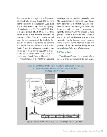
5 0’0’’S 5 0’0’’S border with French Guiana (Figure 11). The gill nets (Figure 12) consist of a fish-
o
o
These fisheries in the ASPSP are directed ing gear that forms horizontal net walls,
10 0’0’’S 10 0’0’’S Figure 12. Bottom gillnet and its structures (left), such as meshes,
o
o
buoys and anchors. Vessel(right) of the gillnet fleet.
Atlantic Surface gillnet (below)
Ocean
15 0’0’’S 15 0’0’’S
o
o
o
20 0’0’’N 20 0’0’’N
o
25 0’0’’S Isobath 2000m 25 0’0’’S
o
o
Isobath_300m
Isobath 100m
Isobath 50m
o
30 0’0’’N Exclusive Economic Zone (EEZ) 30 0’0’’N
o
Fishing Efforts (hours)
Value
High : 1039
o
o
35 0’0’’S Low : 0,01 35 0’0’’S
55 0’0 W 50 0’0 W 45 0’0 W 40 0’0 W 35 0’0 W 30 0’0 W 25 0’0 W
o
o
o
o
o
o
o
o
o
o
o
o
o
o
0 265 530 1.000 1.590 2.120 2.860
Kilometers
Source: Authors based on Global Fishing Watch (2022). (https://globalfishingwatch.org/) Source: Modified from Cochrane (2005) and FAO Fishing Gear Type Collection
746 BLUE ECONOMY Fishing Exploitation in the Brazilian Economic Zone 747
746 ECONOMIA AZUL