
Page 241 - Economia Azul - versão: inglês
P. 241
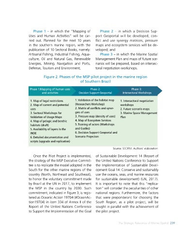
Table1. Estimated cost of implementing the MSP by regions and nationally.   Phase 1 – in which the “Mapping of   Phase 2 –  in which a Decision Sup-
 Values for the year 2021  Uses and  Human Activities” will  be car-  port Geoportal will be developed, con-
                   ried out. Planned for the next 10 years   flict and use synergy matrices, pressure
 ÁREA MARINHA   CUSTO ESTIMADO (R$)  in the southern marine region, with the   maps and ecosystem services will be de-
                   publication of 10 Sectoral Books, namely:   veloped; and
 North Region   7 millions
                   Artisanal Fishing, Industrial Fishing, Aqua-  Phase 3 – in which the Marine Spatial
 Northeast Region   10 millions  culture,  Oil  and  Natural  Gas,  Renewable   Management Plan and maps of future sce-
 Southeast Region   8 millions  Energies, Mining, Navigation and Ports,   narios will be prepared, based on intersec-

 South Region   5 millions  Defense, Tourism and Environment;  toral negotiation workshops.
 All Blue Amazon   30 millions  Figure 2. Phases of the MSP pilot project in the marine region
 Source: SECIRM. Author’s elaboration             of Southern Brazil

 the MSP, which demonstrates greater polit-  ed by an Executive Committee under the   Phase 1:Mapping of human uses   Phase 2:   Phase 3:
 ical commitment to commitments assumed  coordination of the Brazilian Navy, within   and activities  Decision Support Geoportal  Intersectoral Workshops
 externally  in  international  forums,  such  as  the scope of the Interministerial Commis-
 those of UNESCO, but also internally, for the  sion for Sea Resources (CIRM), through its   1. Map of legal restrictions  1. Validation of the habitat map   1. Intersectoral negotiation
                                               (Researchers Workshop)
 political, social, environmental, and econom-  own  Executive  Secretariat  (ESCIRM).  Ad-  2. Map of current and potential   2. Matrix of conflicts and syner-  workshops
 ic benefits. to be raised (VIOLANTE, 2021a).  ditionally,  the  MSP  Executive  Committee   uses  gies of uses  2. Future scenario maps
                    3. Sectoral Workshops for
                                                                           3. Marine Space Management
 It should be noted that the MSP is one  established the requirements and steps for   Validation of Usage Maps  3. Pressure map (density of uses)  Plan
 of the 11 Actions of the X Sectorial Plan for  its implementation in the country, which   4. Map of pelagic and benthic   4. Map of Ecosystem Services
 Sea Resources (X SPSR), approved by Decree  should start with a Pilot Project in the ma-  habitats (draft)  5. Training of actors (Workshops
 No. In addition, the MSP Action is conduct-  rine region of Southern Brazil.  5. Availability of layers in the   and Guides)
                    INDE                       6. Decision Support Geoportal and
 4. National MSP Pilot Project  6. Detailed documentation and   Scenario Projection
                    scripts (upgrade and replication)
 The  choice  of the  southern  marine  re-  er, for the northern region of Brazil, due   Source: SECIRM. Authors’ elaboration
 gion was basically motivated by the follow-  to the border with French Guiana (French
 ing factors:   departmental state). On that occasion, ne-  Once the Pilot Project is implemented,   of Sustainable Development 14 (Report of
 .   Representativeness, its marine area  gotiations between the Brazilian State and   the strategy of the MSP Executive Commit-  the United Nations Conference to Support
 corresponding to 13% of the entire area of  France will be necessary; and  tee is to replicate the model adopted in the   the Implementation of Sustainable Devel-


 the Amazônia Azul (Blue Amazon);  .   Concentration of several research insti-  South for the other marine regions of the   opment Goal 14: Conserve and sustainably
 .   Relevance, concentrates various marine  tutions with a tradition in coastal and marine   country (North, Northeast and Southeast),    use the oceans, seas, and marine resources
 ecosystems, conservation units, in addition to  studies in the three states of the South region   to honor the voluntary commitment made   for sustainable development) (UN, 2017).
 diversified and expressive economic activities;  (PR – UFPR; SC–UFSC and UNIVALI; RS –UFPel,   by Brazil at the UN in 2017, to implement   It is important to note that this “replica-
 .   Availability of minimum marine data  with the Center for Strategic Studies and Ma-  the MSP in the country by 2030. Such   tion” will consider the peculiarities of other
 and metadata for MSP implementation;  rine Spatial Planning (CEDEPEM), in partner-  commitment, indicated in Figure 3, is regis-  national regions. Furthermore, the factors
 .   Maritime border with another coun-  ship with NEA-UFF; FURG, UFRGS and IFRS).  tered as Oceanic Action 19704 (#OceanAc-  that were preponderant for choosing the
 try, the experience to be acquired with the   The Pilot Project foresees three Phases,   tion19704) in item 334 of Annex II of the   South Region, as a pilot project, will be
 implementation of the MSP in the border  as shown in Figure 2, each with a duration   Report of the United Nations Conference   sought in parallel with the achievement of
 region with Uruguay will be relevant, lat-  of 12 months:  to Support the Implementation of the Goal   the pilot project.


 238    BLUE ECONOMY                                                      The Strategic Relevance of Marine Spatial  239