
Page 721 - Economia Azul - versão: inglês
P. 721
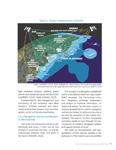
The Amazônia Azul (Blue Amazon) Man-  Amazônia Azul (Blue Amazon), but also to   Figure 2 - Graphic representation of SisGAAz
 agement System (SisGAAz) stands out for its   the sustainable use of its potential and the
 scientific-technological intensity and its mis-  environmental preservation of this vast area.
                                                                   SIMMAP
 sion is to “continuously monitor and protect   In addition, SisGAAz aims to increase   MAR MON SYS SUPP PETRO ACT
 the maritime areas of interest and inland   the country’s Maritime Situational Aware-  SAR  SATELLITE
 waters, their living and non-living resources,   ness, through the development of “a struc-  RADAR  SIR
 their ports, vessels and infrastructure, in the   ture that encompasses data collection,   RADIOGONIOM
 face of threats, emergencies, environmental   monitoring, sensors of naval and air assets   INTEGRATED
                                                       SYSTEM
 disasters, hostilities or illegalities, in order to   and the correct analysis of the facts, allow-
                                     VTS
 contribute to the security and defense of   ing a quick and accurate response” in the   SHIP TRAFFIC
 the Amazônia Azul (Blue Amazon) and to   occurrence of episodes in national waters   SERVICE
 national development” (MARINHA DO BRA-  (FARIA, 2012, p. 220).
 SIL, 2021). The main challenges to its full   It is also relevant to point out the techno-
 development include increasing the acquisi-  logical drag produced by the development of   AIS  PROT PLATFORMS
 tion and monitoring, analysis, and fusion of   SisGAAz translated, above all, into possibili-  AUTOMATIC
 large volumes of data; implement the com-  ties of approximation between defense and   IDENTITY
                            SYSTEM
 munications and IT structure for navigation   Science, Technology, and Innovation (ST&I)
 safety; and manage the lifecycle and oper-  policies, providing advances in the search for
 ating costs of such a structure.  autonomy and endogenous development of   LRIT
 In terms of monitoring, the use of satel-  defense solutions in the country (ANDRADE   LONG DISTANCE
 lites, radars and sensing equipment is fore-  et al., 2019).  In this sense, the development   SHIP IDENTITY
                          SYSTEM
 seen, allowing the integration with other   of technologies as a fundamental constituent
 systems and with information and decision   part of maritime power in the 21st century   Source: LAMPERT; COSTA, 2020. Available at: <https://www.marinha.mil.br/sisgaaz-prote-
                                    cao-e-monitoramento-das-aguas-jurisdicionais-brasileiras>. Access on: April 10, 2022
 support networks. With regard to protection,   stands out (TILL, 2018).
 the aforementioned creation  of COMPAAz   Officially instituted in 2009, SisGAAz has   high resolution cameras, satellites, patrol   The concept of e-Navigation established
 represents an important step in the articula-  gone through different stages over the last   aircraft and unmanned aerial vehicles (UAV)   by the International Maritime Organization
 tion of the Operational Sector of the Navy for   decade, highlighting the development of a   (LAMPERT; COSTA, 2020; MANSO, 2013).  (IMO) comprises “the harmonized collec-
 the implementation of SisGAAz in its fullness.  pilot project in the state of Rio de Janeiro –   Fundamental for the management and   tion, integration, exchange, presentation
 SisGAAz was conceived as “a monitor-  especially in the regions of Guanabara Bay,   monitoring of the Amazônia Azul (Blue   and analysis of maritime information, on
 ing and control system related to the inter-  Cabo Frio and Ilha Grande. In this phase, still   Amazon), SisGAAz connects and instru-  board and ashore, by electronic means, to
 national concept of maritime security” and   in progress, short- and medium-range radars   ments several other systems, such as e-Nav-  improve quayside berth-to-berth navigation
 designed to become the main command   are incrementally used – up to 50 miles. Later,   igation, which will be discussed below.  and services related to safety and security at
 and control system of the Brazilian Navy,   long-range monitoring will also be incorpo-  sea and the protection of the marine envi-
 allowing “the management of activities   rated – up to 200 miles off the Brazilian coast   3.2 e-Navigation and its contribution   ronment. The focus is “to meet the present
 related to the sea that involve surveillance,   – using surface wave Over the Horizon (OTH)   to the Economy  and future needs of users through the har-
 monitoring, pollution prevention, natural   radars (LAMPERT; COSTA, 2020).  Just as aircraft and airports communicate     monization of maritime navigation systems
 resources, among others” (BRASIL, 2016, p.   After its complete implementation, Sis-  effectively and know if there will be any   and support services on land”.
 60). Therefore, the applicability of this sys-  GAAz will operate from the integration of   changes in practically real time, so will the   The need for harmonization and stan-
 tem can be observed in initiatives not only   different equipment and systems, composed   relationships between ships and ports in   dardization of land services resulted in the
 related to the defense of sovereignty in the   of  radars  located on  land  and  on vessels,   the future (AGUIAR, 2022).  elaboration of the maritime services portfolio


 718   BLUE ECONOMY                                                      Security, Defense and Economy of the Sea 719