Page 388 - Economia Azul - versão: inglês
P. 388

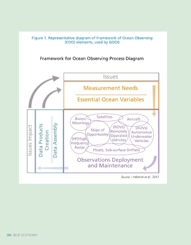
Figure 2. Proposal for a new GOOS-Brasil organizational structure
                   Figure 1. Representative diagram of Framework of Ocean Observing
                                       (FOO) elements, used by GOOS                                                                                           GOOS-BRASIL


                                                                                                                                                        COI        OVERALL      SECIRM
                                                                                                                                                                   COORDINATION
                        Framework for Ocean Observing Process Diagram

                                                                                                                                          MMA                MEC           MME        MD         MCTI

                                                             Issues
                                                                                                                                    AUTONOMOUS        REMOTE          FIXED         MOBILE
                                                                                                                                     PLATFORMS      PLATFORMS       PLATFORMS     PLATFORMS        BEST
                                                 Measurement Needs                                                                                                                                 PRACTICES

                                                                                                                                       GLIDERS/                     TIDE GRAPHS                    HYDRODYNAMIC
                                              Essential Ocean Variables                                                                AUV/ ASV                                     HYDROGRAPHY    MODELING
                                                                                                                                                      REMOTE
                                                                                                                                                      SENSING       SHALLOW                        MODELING
                                                                                                                                       DERIVATIVES/                 ANCHORAGES                     WAVE
                                                                                                                                       ARGO                         DEEP WATER      SHIPS OF
                                            Buoys,       Satellites       Aircraft                                                                                  ANCHORAGES      OPPORTUNITY    DATA
                                           Moorings   Ships of   Remotely      (AUVs)                                                                                 TERRESTRIAL   MARINE ANIMAL   NETWORK
                   Issues Impact  Data Products  Creation  Data Assembly  Frequency  Floats, Sub-surface Drifters                                                                           Source: GOOS-Brasil, 2022
                                                                  (ROVs)
                                                                                                                                                                                    TRACKING
                                                                                                                                                                    STATIONS
                                                                             Autonomus
                                                   Opportunitiy
                                                                 Operated
                                                                             Underwater
                                           (HF) High,
                                                                  Vehicles
                                                                               Vehicles
                                            Radar
                                              Observations Deployment                                                            4. Other Ocean observation and modeling systems available in Brazil
                                                    and Maintenance                                                              Amazon Coastal Observatory (OCA)         of helping several socioeconomic sectors in
                                                                                                                                                                          the region, based on hydrodynamic models
                                                                                                                                    Due to the territorial dimension, high   at a regional scale (the entire coastal zone
                                                                       Source: Lindstrom et al., 2012                            complexity  and  importance  of  the  Ama-  of Amazon) and at a local scale (small estu-

                                                                                                                                 zon coastal zone in the global context, the   aries and floodplains). In addition, OCA de-
                                                                                                                                 Coastal Observatory of the Amazon (OCA)   velops citizen science projects to integrate
                                                                                                                                 was created to systematize and standard-  scientific and traditional knowledge on
                                                                                                                                 ize the meteoceanographic data that have   marine environmental monitoring issues. In
                                                                                                                                 been collected, making them available and   particular, the Observatory has been sup-
                                                                                                                                 promoting multidisciplinary scientific devel-  porting scientific development and publica-
                                                                                                                                 opment in the region. Meteoceanographic   tions on fundamental and peculiar themes
                                                                                                                                 operational models are being developed by   for that region, such as tidal propagation
                                                                                                                                 the OCA-Predict platform, with the purpose   (ROLLNIC and ROSÁRIO, 2013; PRESTES


     386   BLUE ECONOMY                                                                                                                                                                                Ocean Observation 387
     386   BLUE ECONOMY
   383   384   385   386   387   388   389   390   391   392   393